Is the 2024 Atlantic hurricane season standing up to predictions?

Here's what past seasons may tell us about this year's hurricane forecast.

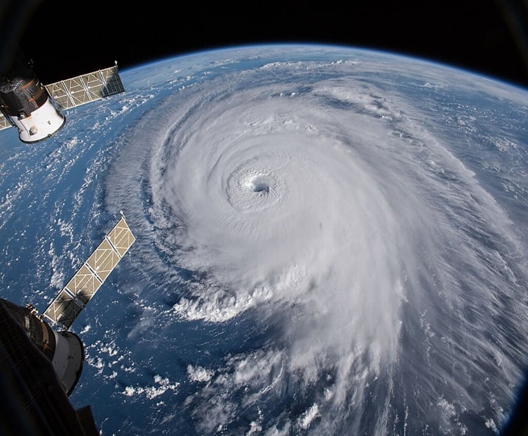
While seasonal hurricane forecasts are skillful, they are also far from perfect. This is a look at Hurricane Florence in 2018 as viewed from International Space Station. (NASA Goddard Space Flight Center/Wikipedia Commons)

Seasonal predictions for the 2024 Atlantic Hurricane season indicate it could be one of the most active hurricane seasons on record. Colorado State University, a leading hurricane season forecaster, has raised their latest forecast, issued in July, to 25 named storms. If this forecast proves accurate, this would put the 2024 hurricane season in rare company, with only the 2005 and 2020 seasons recording 25 or more named storms.

Part of the reason forecasters are calling for so many storms in the Atlantic this year is the elevated sea surface temperatures, which have been significantly above normal. In fact, temperatures in the northern Atlantic have been near or above record highs for the entire year, with temperatures currently around 2 degrees Fahrenheit above the 1982-2011 average according to Climate Reanalyzer. Hurricane Beryl, which became the earliest Atlantic Category 5 hurricane on record, provided some indication of what these elevated sea surface temperatures may mean for this season.

Related: A closer look at Hurricane Beryl damage, recovery efforts

Despite this, in the first two months of the Atlantic hurricane season, only four named storms have been officially recorded in the Atlantic. A big reason for the relatively limited activity has been Saharan dust. Saharan dust is not unusual for this time of year, typically peaking over the Atlantic in June and July, but the dust levels in July 2024 have been well above average.

In fact, this July is the second dustiest July on record over the past 23 years. This dust creates hostile conditions for tropical development and has been the primary reason why we have not seen a tropical storm since Beryl was downgraded on July 8. Although dust levels are now decreasing, potentially opening the door for tropical development in the month of August, we must now wonder, do we have any chance of making it to 25 named storms this season after this long hiatus?

While predicting the future is never easy, we looked at the past 25 Atlantic hurricane seasons (1999 to 2023) to uncover insights that might help us better understand where the remainder of this season may take us. Through July 31, on average, the Atlantic sees 3.05 named storms, making 2024 an average season to date. Sixteen of the seasons (64%) had at least three named storms through this point in the season. Notably, only two seasons had six or more named storms at this point in the season, 2005 (7) and 2020 (9), which as mentioned above went on to become the most active seasons in recorded history in terms of named Atlantic storms.

Looking back

In 2020, the number of named storms, hurricanes and major hurricanes all ended up exceeding the seasonal outlooks issued. The National Oceanic and Atmospheric Administration (NOAA) forecast as of May 2020 estimated 13-19 named storms, 6-10 hurricanes, and 3-6 major hurricanes and only adjusted this upward to 19 to 25, 7 to 11, and 3 to 6 respectively in their updated August forecast.

By the end of the season, there were 30 named storms, 14 hurricanes, and 7 major hurricanes. While 2020 seasonal predictions were ultimately too low, the opposite happened in 2013, where there were just 2 hurricanes, none of which reached major hurricane status, despite the NOAA May forecast predicting 7 to 11 hurricanes and 3 to 6 major hurricanes.

This highlights that while seasonal hurricane forecasts are skillful, they are also far from perfect.

Related: The costliest hurricanes to hit the U.S.

If 2024 is going to produce an additional 22 named storms, the four that have occurred thus far would represent just 12% of the total named storms for the season. And while eight out of the past 25 seasons produced 88% or more of their seasonal named storms from August 1 onward, it is notable that 6 of these 8 seasons also ended with 15 or fewer named storms, while the other two seasons recorded 18 (2019) and 19 (2010) named storms.

That said, one season, 2005, produced 22 named storms from August 1 onward, and 2020 saw 21 named storms during this period. However, both seasons also started at record paces on their way to becoming the two most active seasons in terms of named Atlantic storms, as previously mentioned.

If 2024 is to join these seasons as the most active in recorded history, it would need to achieve this in an unconventional manner, by generating record level activity over the coming months on the heels of an average start to the season.

Regardless of the ultimate number of storms for the 2024 season, many times a hurricane season is remembered more for its impacts rather than the number of named storms it had. The vast majority of named storms, hurricanes and even major hurricanes never make landfall and thus from an insurance perspective, have little or no impact. Of the storms that do make it to land, the exact track and intensity of the storm are major factors in determining insured losses and slight differences in the storm track can make a significant difference in the outcome in terms of insured losses.

One example of this comes in comparing recent hurricanes Idalia and Ian. Hurricane Ian impacted the Gulf Coast of Florida in late September 2022 as a Category 5 hurricane with significant impacts in the Cape Coral and Fort Myers metro area, one of the fastest growing areas in the country over the past 20 years. The result was an estimated $118.5 billion in both insured and uninsured damages.

Meanwhile, Hurricane Idalia, a Category 4 hurricane that made landfall in late August 2023 along the Gulf Coast of Florida, made its landfall in the Big Bend region, a far less populated area and therefore resulted in far less damage at an estimated $3.6 billion. Both storms were major hurricanes impacting the west coast of Florida, but the track and intensity of these storms made a significant difference in damages that occurred.

Beyond the intensity and track of the storms, for 2024 we must also continue to recognize the impacts of the growing number of exposures, owing to population growth and the rising cost of goods and services due to inflation, on the ultimate insured losses of any tropical events.

According to Verisk’s 360Value data, inflation has increased reconstruction costs for residential structures nearly 6% in Florida and nearly 5% in Georgia over the trailing twelve months. Looking at the roughly two-year period from the time Hurricane Ian hit Florida through July of this year, residential structure reconstruction costs in Florida have increased over 15% and commercial structure reconstruction costs have increased nearly 20%. Therefore, we will continue to see that overall losses for any storms continue to rise relative to historical values and what would have occurred if the same storm had hit in years prior.

The 2024 Atlantic hurricane season has already delivered us one record in Beryl’s early rise to a Category 5 hurricane. However, only time will tell how the remainder of the season will play out.

With peak hurricane season still about a month away, the 2024 season has plenty of time to prove whether seasonal predictions are a boom or a bust.

Tory Farney is the vice president of Weather Solutions and Cortney Miller is the director of Weather Solutions at Verisk. This article is published with permission and may not be reproduced.

See also: