Astronaut Reid Wiseman left for the International Space Station on May 29 and currently serves as flight engineer for Expedition 41. During his time on the ISS, he has been active on Twitter sharing some insights as well as many amazing photos.
Earlier today, Wiseman shared this incredible image of Tropical Storm Arthur (credit to Reid Wiseman, and used with permission from NASA).
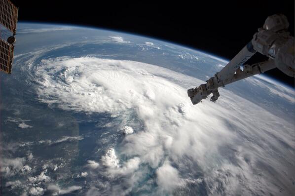
Wiseman tweeted along with the picture, "Just flew over TS #Arthur – hoping it heads to sea. Looks mean." Give him a follow and check out some of his other pictures from the ISS. It is well worth it.
If that image is not enough, here's another striking one from closer to the ground of a rainband in Arthur. This photo was taken by a NOAA aircraft and posted to Twitter (used with permission from the NOAA Aircraft Operations Center).
As for the latest information on the storm, the National Hurricane Center has issued a hurricane watch and tropical storm warnings associated with Arthur, which remains off the coast of Florida but is now moving north.
"The data indicate that Arthur remains with an initial intensity of 50 knots, the NHC says in its 2 p.m. update. "These strong winds are currently confined to the eastern semicircle. Although the cloud pattern on satellite is somewhat ragged, the radar presentation is fair with numerous rainbands."
A tropical storm warning is in effect for the North Carolina coast from Little River Inlet to the North Carolina/Virginia border, eastern Albermarle Sound and Pamlico Sound.
A hurricane watch is in effect for Bogue Inlet to Oregon Inlet, North Carolina and Pamlico Sound. A tropical storm watch covers south of Little River Inlet to South Santee River, South Carolina.
The NHC further says interests along the east coast in southeastern New England should monitor the progress of the storm.
As noted by the Miami Herald, the tropical storm watch for Florida has been called off.
Arthur is enduring effects from dry air, causing a lopsided structure that the NHC says “suggests that Arthur will not strengthen quickly in the short term,” but given “an otherwise favorable environment of warm water and weak wind shear, all of the intensity guidance shows the cyclone becoming a hurricane in about 36 hours, and so does the official forecast.”
The current track shows Arthur forming into a hurricane sometime on Thursday before either striking the North Carolina coast or tracking just east of the coast (see forecast image below).
Credit: NOAA
North Carolina Governor Pat McCrory declared a state of emergency “due to the approach of Tropical Storm Arthur.” The declaration covers the counties of Beaufort, Bertie, Bladen, Brunswick, Camden, Carteret, Chowan, Columbus, Craven, Currituck, Dare, Duplin, Gates, Hertford, Hyde, Jones, Martin, New Hanover, Onslow, Pamlico, Pasquotank, Pender, Perquimans, Pitt, Tyrrell and Washington.
Want to continue reading?
Become a Free PropertyCasualty360 Digital Reader
Your access to unlimited PropertyCasualty360 content isn’t changing.
Once you are an ALM digital member, you’ll receive:
- Breaking insurance news and analysis, on-site and via our newsletters and custom alerts
- Weekly Insurance Speak podcast featuring exclusive interviews with industry leaders
- Educational webcasts, white papers, and ebooks from industry thought leaders
- Critical converage of the employee benefits and financial advisory markets on our other ALM sites, BenefitsPRO and ThinkAdvisor
Already have an account? Sign In Now
© 2024 ALM Global, LLC, All Rights Reserved. Request academic re-use from www.copyright.com. All other uses, submit a request to [email protected]. For more information visit Asset & Logo Licensing.